Overture Mapsのデータを空間検索するメモ。
WherobotsDBを利用
WherobotsDBを利用するために「SedonaContext」オブジェクトを作成します。
from sedona.spark import *

config = SedonaContext.builder().getOrCreate()
sedona = SedonaContext.create(config)
Wherobots Spatial CatalogのOpen Data Catalogを確認
Open Data Catalogでは、Overture MapsやFoursquareのデータをプリセットで利用できます。
Open Data Catalogの一覧を表示します。
sedona.sql("SHOW SCHEMAS IN wherobots_open_data").show()+--------------------+
| namespace|
+--------------------+
| overture|
| overture_2024_02_15|
| overture_2024_05_16|
| overture_2024_07_22|
|overture_2024_01_...|
|overture_2024_05_...|
|overture_2023_07_...|
|overture_2024_06_...|
|overture_2024_09_...|
|overture_2024_08_...|
|overture_2024_10_...|
|overture_2024_03_...|
|overture_2024_04_...|
|overture_2023_10_...|
|overture_2023_11_...|
|overture_2024_06_...|
|overture_2024_07_...|
|overture_2024_02_...|
|overture_2023_12_...|
|foursquare_2024_1...|
+--------------------+
only showing top 20 rowsOverture Mapsデータベースのテーブルを表示します。
sedona.sql("SHOW tables IN wherobots_open_data.overture").show(truncate=False)+---------+-----------------------------+-----------+
|namespace|tableName |isTemporary|
+---------+-----------------------------+-----------+
|overture |admins_administrativeBoundary|false |
|overture |admins_locality |false |
|overture |buildings_building |false |
|overture |places_place |false |
|overture |transportation_connector |false |
|overture |transportation_segment |false |
+---------+-----------------------------+-----------+Overture Mapsの「places_place」テーブルのスキーマを表示します。
sedona.table("wherobots_open_data.overture.places_place").printSchema()root
|-- id: string (nullable = true)
|-- updatetime: string (nullable = true)
|-- version: integer (nullable = true)
|-- names: map (nullable = true)
| |-- key: string
| |-- value: array (valueContainsNull = true)
| | |-- element: map (containsNull = true)
| | | |-- key: string
| | | |-- value: string (valueContainsNull = true)
|-- categories: struct (nullable = true)
| |-- main: string (nullable = true)
| |-- alternate: array (nullable = true)
| | |-- element: string (containsNull = true)
|-- confidence: double (nullable = true)
|-- websites: array (nullable = true)
| |-- element: string (containsNull = true)
|-- socials: array (nullable = true)
| |-- element: string (containsNull = true)
|-- emails: array (nullable = true)
| |-- element: string (containsNull = true)
|-- phones: array (nullable = true)
| |-- element: string (containsNull = true)
|-- brand: struct (nullable = true)
| |-- names: map (nullable = true)
| | |-- key: string
| | |-- value: array (valueContainsNull = true)
| | | |-- element: map (containsNull = true)
| | | | |-- key: string
| | | | |-- value: string (valueContainsNull = true)
| |-- wikidata: string (nullable = true)
|-- addresses: array (nullable = true)
| |-- element: map (containsNull = true)
| | |-- key: string
| | |-- value: string (valueContainsNull = true)
|-- sources: array (nullable = true)
| |-- element: map (containsNull = true)
| | |-- key: string
| | |-- value: string (valueContainsNull = true)
|-- bbox: struct (nullable = true)
| |-- minx: double (nullable = true)
| |-- maxx: double (nullable = true)
| |-- miny: double (nullable = true)
| |-- maxy: double (nullable = true)
|-- geometry: geometry (nullable = true)
|-- geohash: string (nullable = true)Spatial SQLで空間検索
Spatial SQLを利用することでさまざまな空間検索が実行できます。
Overture Mapsの「places_place」テーブルから「places」ビューを作成します。
sedona.table("wherobots_open_data.overture.places_place").createOrReplaceTempView("places")名前・カテゴリー・ポイント座標の属性とポイントデータを取得します。
sedona.sql("SELECT categories.main AS category, names.common[0].value AS name, geometry FROM places LIMIT 20").show(truncate=False)+---------------------+----------------------------------+------------------------------+
|category |name |geometry |
+---------------------+----------------------------------+------------------------------+
|taiwanese_restaurant |台湾料理四季紅 |POINT (136.885079 35.343057) |
|japanese_restaurant |いろ川 |POINT (139.848961 35.739373) |
|farm |株式会社阿部農園 |POINT (139.0049956 37.7329319)|
|train_station |岩波駅 |POINT (138.919082 35.215899) |
|japanese_restaurant |甲南そば |POINT (135.27482 34.728534) |
|restaurant |Cuatro |POINT (138.8529754 35.1067167)|
|smoothie_juice_bar |ゴクゴク 横浜ワールドポーターズ店|POINT (139.6385154 35.4541338)|
|hotel |Curation Hotel |POINT (139.0785116 35.1066403)|
|asian_restaurant |集来軒 |POINT (135.470227 34.717611) |
|professional_services|株式会社CDF |POINT (135.1936619 34.6962007)|
|public_plaza |深見歴史の森スポーツ広場 |POINT (139.464748 35.491567) |
|pet_store |うさぎ専門店ちゅらうさぎ |POINT (138.2966425 34.8537383)|
|japanese_restaurant |無添くら寿司横浜長津田店 |POINT (139.497489 35.521179) |
|health_and_medical |大滝漢方堂 |POINT (136.5 36.05) |
|japanese_restaurant |焼き鳥酒場 ちょりちょり |POINT (139.5350146 36.0305335)|
|eat_and_drink |味のじゅん天 |POINT (140.386382 37.399886) |
|japanese_restaurant |まご茶亭 |POINT (139.071774 35.09486) |
|gym |スマートフィット100大塚店 |POINT (140.408632 36.383624) |
|NULL |法隆寺駅 |POINT (135.739107 34.601617) |
|bar |布施酒場かい |POINT (135.564394 34.663048) |
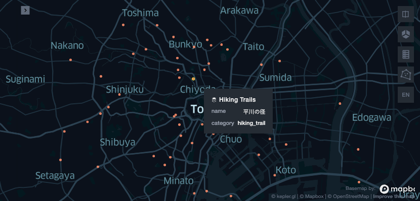
+---------------------+----------------------------------+------------------------------+指定ポイントから半径10km以内にある「hiking_trail」を取得します。
sedona.sql("""
SELECT names.common[0].value AS name, categories.main AS category, geometry FROM places WHERE ST_DistanceSphere(ST_GeomFromWKT('POINT (139.7645 35.6811)'), geometry) < 10000 AND categories.main = 'hiking_trail' LIMIT 20
""").show(truncate=False)+-----------------------------+------------+------------------------------+
|name |category |geometry |
+-----------------------------+------------+------------------------------+
|玉川上水旧水路幡ヶ谷緑道 |hiking_trail|POINT (139.678356 35.676208) |
|向日葵の小径 |hiking_trail|POINT (139.756216 35.674825) |
|荒木坂 |hiking_trail|POINT (139.7393195 35.7115361)|
|目黒川緑道池尻大橋駅側入口 |hiking_trail|POINT (139.6854 35.651325) |
|芝浦アイランド 遊歩道 |hiking_trail|POINT (139.750809 35.63663) |
|大塚バラロード |hiking_trail|POINT (139.72557 35.729693) |
|解剖坂 |hiking_trail|POINT (139.759613 35.721601) |
|足立の平成五色桜 |hiking_trail|POINT (139.770207 35.759781) |
|芸術の散歩道 |hiking_trail|POINT (139.77332 35.7163) |
|玉川上水旧水路世田谷緑道 |hiking_trail|POINT (139.662694 35.670916) |
|三段坂 |hiking_trail|POINT (139.769306 35.718932) |
|飛鳥大坂 |hiking_trail|POINT (139.737485 35.750156) |
|目黒川東海禅寺裏遊歩道 |hiking_trail|POINT (139.739045 35.615981) |
|山王男坂 |hiking_trail|POINT (139.740707 35.674686) |
|レインボープロムナード 台場口|hiking_trail|POINT (139.775662 35.635127) |
|大横川の桜並木 |hiking_trail|POINT (139.794909 35.671448) |
|白鷺坂 |hiking_trail|POINT (139.736717 35.723212) |
|三平坂 |hiking_trail|POINT (139.731583 35.758) |
|玉川上水旧水路初台緑道 |hiking_trail|POINT (139.687152 35.680788) |
|レインボープロムナード 芝浦口|hiking_trail|POINT (139.759193 35.637868) |
+-----------------------------+------------+------------------------------+空間検索結果のDataFrameを作成します。
trails_df = sedona.sql("""
SELECT names.common[0].value AS name, categories.main AS category, geometry FROM places WHERE ST_DistanceSphere(ST_GeomFromWKT('POINT (139.7645 35.6811)'), geometry) < 10000 AND categories.main = 'hiking_trail'
""")
空間検索結果を可視化
SedonaKeplerやSedonaPyDeckを利用し空間検索結果を可視化できます。
SedonaKeplerで空間検索結果を可視化します。
SedonaKepler.create_map(trails_df, "Hiking Trails")
- 参考文献
Wherobots


